
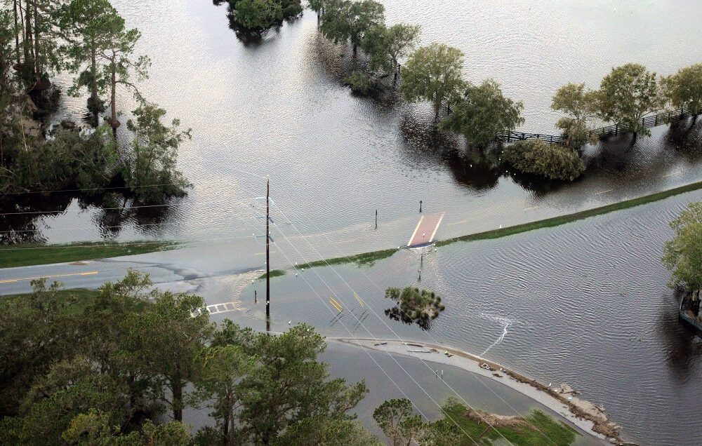
With eight major river basins, South Carolina is prone to catastrophic floods. Flooded roads and homes have become a familiar sight in many parts of the state.
Research shows these flood events are expected to occur more frequently and likely will intensify in the future. During flooding events, stakeholders must both balance the demands these events impose on decision-making processes and attend to the service delivery infrastructure of affected communities. Four Clemson University researchers are part of a national team that has developed a Flood Evacuation Tool to help forecast floods, identify at-risk roads and verify safe evacuation routes.
The tool partners artificial intelligence (AI) with human knowledge. Researchers are using this human-AI teaming (HAT) partnership to create an intelligent model for addressing flood evacuation decisions in isolated South Carolina rural coastal communities. Current flood evacuation models include Geographic Information System (GIS) and infrastructure planning approaches, which do not use artificial intelligence.
“Supporting humans and AI machines as teammates in flood evacuation decisions relies on a carefully designed system with the capability for monitoring, analyzing, responding and executing,” said Vidya Samadi, Department of Agricultural Sciences assistant professor and Clemson Hydrosystem and Hydroinformatics Research Group director. “The goal of our research is to achieve a trusting partnership between humans and AI machines by designing a flood evacuation system that combines AI, geospatial data and river hydraulic parameters to forecast floods, identify at-risk roads and generate evacuation rerouting plans.”
Tools, including National Weather Service (NWS) flood warning alerts, GIS, and transportation infrastructure planning, are used to make flood evacuation decisions in South Carolina. This new tool leverages AI and human capabilities at a local scale, such as a road segment, to use in flood evacuation decision-making processes.
Pamela Murray-Tuite, director of the Clemson University Institute for Sustainable Education and a civil engineering professor, used her knowledge of evacuation modeling in the design.
“This tool could help identify areas at risk of flooding that would need evacuation and areas that are potentially hazardous during an evacuation,” Murray-Tuite said.
Data from the United States Geological Survey’s National Water Data Portal and the National Weather Service Forecast, as well as social media data, are being used to evaluate and forecast road flooding to provide rerouting recommendations.
Nina Hubig, an assistant professor with the Clemson School of Computing, is using her AI and data science knowledge for the project. In addition, Rishav Karanjit, a Clemson graduate student from the School of Computing, is helping the team with workflow implementation and design.
This free tool has been tested in the Lowcountry of South Carolina and is available online.
Risk management
Evacuation from flood-prone areas is a challenge for flood risk management. Will Rochester, Berkeley County Emergency Management Division director, said it will aid in response and recovery efforts of local and federal agencies.
“Flooding seems to be at the top of many jurisdictional hazard vulnerability assessments across South Carolina,” Rochester said. “Where it once was considered more of a Lowcountry problem, many counties even in the Upstate have experienced this hazard with damages to roadways and infrastructure.”
The tool should help improve decision-making at all levels.
“For the emergency management community, this is another tool in the toolbox to be able to combat flooding,” Rochester said. “Planning is a part of emergency management to have an effective response. I see this tool as being able to support that.”
In addition to Clemson scientists, other researchers involved in this study include Keri K. Stephens, a professor in organizational communication technology, as well as a distinguished teaching professor and co-director of the Technology and Information Policy Institute in the Moody College of Communication at The University of Texas at Austin, and Amanda Hughes, an associate professor of computer science at Brigham Young University.
This project received a 2023 Technical Merit Award from the American Society of Civil Engineers. It is funded by the National Science Foundation.
Get in touch and we will connect you with the author or another expert.
Or email us at news@clemson.edu